Sign In | Join Free | My howtoaddlikebutton.com
China Chengdu Wanggan Technology Co., Ltd. logo
Chengdu Wanggan Technology Co., Ltd.
Active Member

5 Years

Home > GPS Land Measuring Instrument >

GNSS GPS HandHeld Land Navigator Multifunctional Agriculture Surveying

Chengdu Wanggan Technology Co., Ltd.
Contact Now

GNSS GPS HandHeld Land Navigator Multifunctional Agriculture Surveying

Brand Name : Wanggan

Model Number : S8

Certification : ISO9001

Place of Origin : China

MOQ : 2

Price : $70-$80

Payment Terms : T/T, Western Union, MoneyGram

Supply Ability : 10000 sets/month

Delivery Time : 10 working days

Packaging Details : 19*15*9cm 0.4kg

Machine name : GPS Land Measuring Instrument

Feature : GPS Navigation Location Finder Survey Equipment

LCD display : 3.15-inch monochrome

Color : Black+Blue

Satellite signals : GPS GLONASS SBAS BeiDou

Package size : 18*14*8cm 0.4kg

Battery : Lithium Battery

Function : Multifunctional Navigation Measurement

Package material : paper box

Contact Now

GPS Land Measuring Instrument Multi-function GNSS GPS HandHeld Land Navigator Agriculture Surveying Device

Multi-functional and multi-requirement design Wanggan S8 locator can do altitude survey, position navigation , travel records, accurate positioning and project lofting.

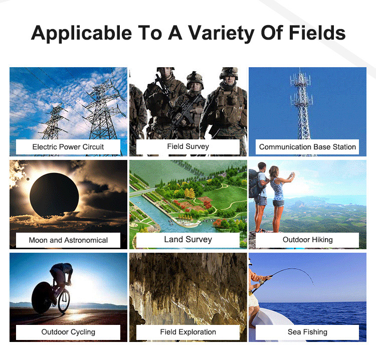
This Wanggan S8 locator device could be used in lots of situations and applicable to a variety of fields, such as electric power circuit, field survey, communication base station, moon and astronomical, land survey, outdoor hiking, outdoor cycling, field exploration and sea fishing

The Function of Lofting

Four Patterns

.(Select Points) Select existing navigation points as lofting points.

.(Equal Division) Setting the number of lofting points,generate equal distance lofting points automatically.

.(Equal Distance) Setting the distance,generate lofting points automatically.

.(User-defined Distance) Setting the distance of the single segment,generate lofting points.

Two Steps

.Select lofting mode

.Accurate lofting following with navigation

The function of Navigation Point

.Get varied and accurate location information

.The function of taking the navigation point automatically

.The function of inputting the collection navigation point manually

The function of navigation route and track

.Customize edit navigation route(Edit navigation points into route)

.Real-time track recording(Travel records)

S8 tractor makes navigation more direct and convenient, Wanggan S8 tractor has real-time navigation, deviating remainder, speed display, waypoint navigation, route navigation and track navigation.

GNSS GPS HandHeld Land Navigator Multifunctional Agriculture Surveying

GNSS GPS HandHeld Land Navigator Multifunctional Agriculture Surveying

GNSS GPS HandHeld Land Navigator Multifunctional Agriculture Surveying

GNSS GPS HandHeld Land Navigator Multifunctional Agriculture Surveying

GNSS GPS HandHeld Land Navigator Multifunctional Agriculture Surveying

GNSS GPS HandHeld Land Navigator Multifunctional Agriculture Surveying

GNSS GPS HandHeld Land Navigator Multifunctional Agriculture Surveying

GNSS GPS HandHeld Land Navigator Multifunctional Agriculture Surveying

GNSS GPS HandHeld Land Navigator Multifunctional Agriculture Surveying


Product Tags:

GPS HandHeld Land Navigator


GNSS Land Navigator


Multifunctional Land Surveying Instrument

      
Wholesale GNSS GPS HandHeld Land Navigator Multifunctional Agriculture Surveying from china suppliers

GNSS GPS HandHeld Land Navigator Multifunctional Agriculture Surveying Images

Inquiry Cart 0
Send your message to this supplier
 
*From:
*To: Chengdu Wanggan Technology Co., Ltd.
*Subject:
*Message:
Characters Remaining: (0/3000)
 
Inquiry Cart 0